The BVRLA has developed an Interactive UK CAZ map as it warns that almost every corner of the UK will be implementing some form of air improvement strategy within the next few years.
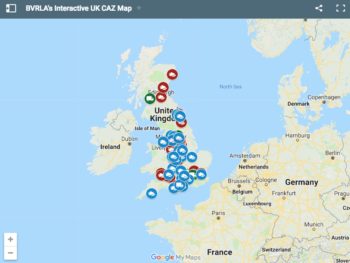
Introduced ahead of the launch of the first clean air zones from 2020 – and with more than 60 local authorities currently considering new clean air measures including the introduction of clean air zones – the map provides a status update on each of the UK local authority areas considering clean air zones, from Ashfield to Wolverhampton.
The map can help businesses plan their vehicle requirements accordingly and forms part of the BVRLA’s work to help ensure fleets are aware of clean air zones.
Research carried out by the association three months ago found only 57% of all UK cars meet CAZ emission requirements. This compares to 94% of the car rental fleet and 75% of leased cars, showing how BVRLA members are leading the way when it comes to adopting cleaner cars.
To access the BVRLA’s interactive UK CAZ map, click here.