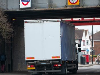
Verified, free-to-use, data on height restrictions of tunnels and bridges is now being made available to help cut the number of bridge strikes across London.

With at least bridge strikes happening across the capital per month, the new dataset is being released by Transport for London (TfL) with the help of Ordnance Survey to help freight and transport operators to help plan journeys better.
Available to access here, the data will cover all bridge structures within the Greater London boundary / M25 and will see structures grouped into five specific groups.
Emily Herreras-Griffiths, travel demand management interim programme director at Transport for London, said: “Every day, millions of road freight deliveries are made across London, and yet, in this digitally connected age, it is still alarming how often bridge strikes can occur.
“Our Vision Zero policy means that we are determined to reduce road and rail danger wherever it occurs. For many years, we have brought together the road freight industry to tackle many issues and I’m delighted that we have been able to work with Ordnance Survey to provide a ‘single source of data’ for bridge heights across London. I encourage all freight operators to use this data to ensure their systems are consistently accurate, helping drivers and their vehicles avoid unnecessary collisions, which can impact both drivers and rail passengers.”
The new dataset is intended to complement ongoing work to limit the adverse impact of deliveries and reduce the number of lorries and vans entering central London in the morning peak by 10% by 2026.
Guidance and toolkits to help businesses better plan and retime their deliveries to avoid the busiest periods in London are available online here.

